
.png)

We’re entering a period of quieter weather across much of the country.
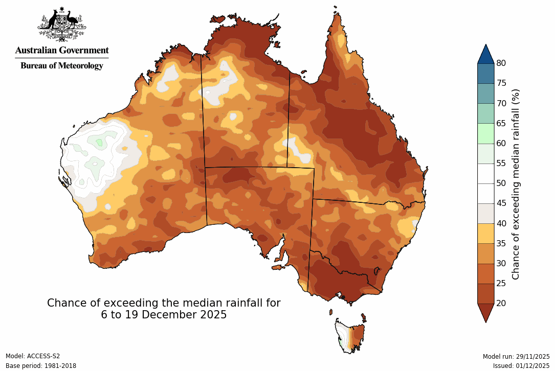
The first few weeks of December are likely to bring below average rain over more than 90% of the country.
The weather pattern has changed.
No longer are we seeing day after day of severe storms in southeast Queensland. The trough isn’t sitting over Queensland into northeast NSW anymore. There will be a trough from time to time, but it’s no longer persistent from day to day.
No longer are we seeing a huge difference in temperature from Queensland and NSW, to Victoria, SA and Tasmania. Instead the heat is able to spread down into the far southeast from time to time - and the cold outbreaks are weaker than in the previous few months. There are still chilly days in the southeast (including the alpine snow that arrived just in time for December 1st), but they’re not as extreme or long lasting - less likely to bring wintry hail and low level snow. .
We’re also missing a connection up to the tropics, so when our weather systems move through they bring hardly any wet weather (away from exposed areas).
Will the weather patterns we saw in November return? Potentially yes.
Our current pattern is reducing the tropical connection as you would expect as the Negative Indian Ocean Dipole comes to an end. But we do have a weak La Nina, and we are surrounded by warmer than average sea temperatures.
These are both moisture generators, and they’ll sit there, ready to go, ready for the next time the weather pattern seeks to connect this moisture to weather systems that are passing through.
In the meantime we’ll see high pressure dominate our pressure pattern. Whenever the centre of the high is to your east then you are on the warm to hot side of the high, and that’ll push hot air from the interior through to the coast. Whenever a trough clips the coast then we take a break with a cool change.
But if the high is broad and ridges across the country, then it brings a stretch of stable weather, and it is only when the moisture in the tropics can pour in once again that we’ll see significant rain return.


.png)